
AGeoABM
Motivation
The COVID-19 crisis exposed a fundamental divide in epidemic modeling approaches. On one hand, we have traditional compartmental models (like SEIR) that use differential equations to track population-level disease states. On the other, we have agent-based models (ABMs) that simulate individual behaviors and interactions. Each approach has distinct advantages and limitations in capturing the complex dynamics of disease spread.
Compartmental Models (SEIR Framework)
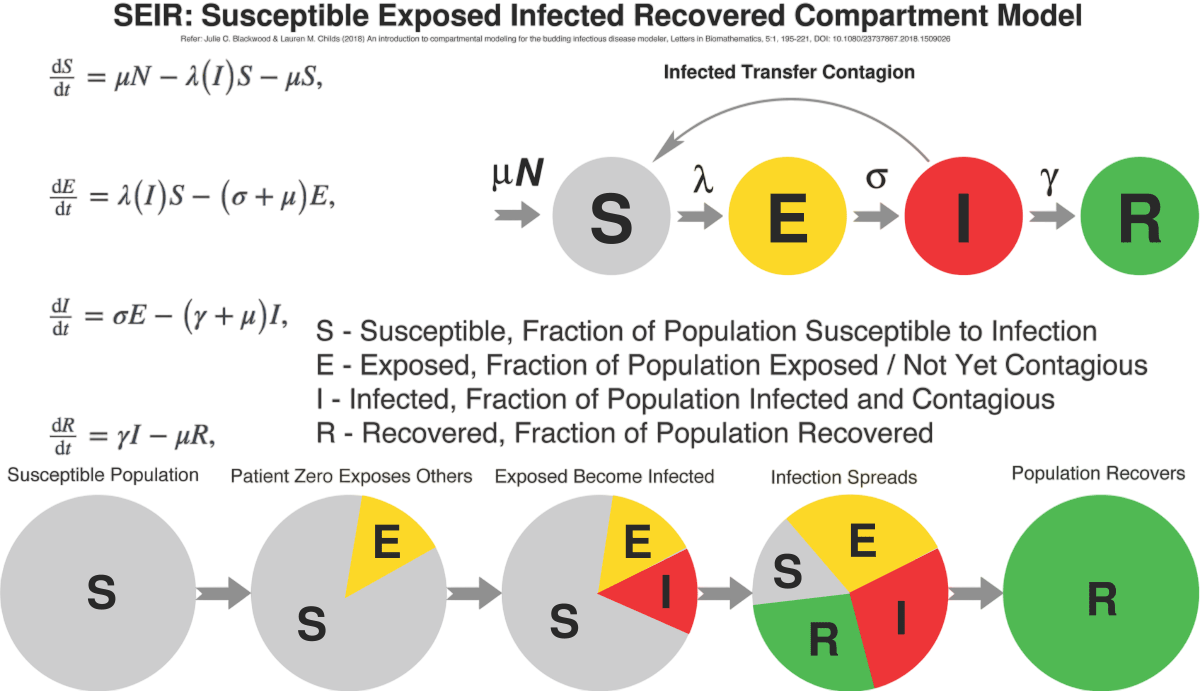
How they work: Population is divided into compartments (Susceptible, Exposed, Infectious, Recovered) with transition rates between them governed by ordinary differential equations.
Classical SEIR-type systems offer clear mathematical structure but face limitations:
- Rely on homogeneous-mixing assumptions that obscure neighborhood-scale dynamics
- Struggle with urban outbreak patterns where contact heterogeneity is crucial
- While parameter-identifiable, may oversimplify real-world transmission networks
Agent-Based Models (ABMs)
How they work: Simulate individual 'agents' (people) with specific behaviors, locations, and interactions, allowing for complex, heterogeneous contact networks and mobility patterns.
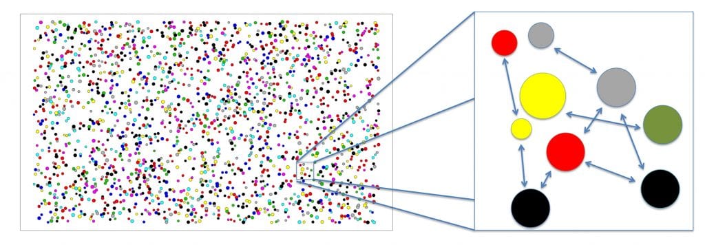
While ABMs capture individual mobility, they often introduce other challenges:
- Frequently use ad-hoc daily schedules or simplified state machines
- May lack connection to well-studied differential-equation disease kinetics
- Face difficulties in calibration and comparative analysis
Abstract
Asymptomatic individuals (agents) have the potential to influence epidemic spread significantly but are difficult to portray accurately. Current models either ignore realistic human behavior or spatial interactions.
Framework Overview
We introduce an open-source framework combining:
- Spatial agent-based modeling
- Real-world geospatial network construction
- Explicit representation of asymptomatic transmission within an SEIR model
Agent Characteristics
Agents are initialized with:
- Demographic categories from census data (age, employment, household structures)
- Individualized daily schedules from data-driven patterns
- Navigation through graph-based networks of real-world locations
Model Flexibility
Originally calibrated for COVID-19, the model:
- Adapts to other infectious diseases with minimal modifications
- Can simulate any U.S. city
- Evaluates mitigation efforts (quarantines, closures, vaccination)
Our Hybrid Approach
AGeoABM bridges this divide through a novel architecture that:
- Maintains rigorous SEIIR compartmental progression for each agent
- Drives location-specific contacts using real mobility and land-use data
- Delivers mechanistically interpretable, geographically precise projections
Key Findings
This fusion enables policy-ready epidemic forecasts at an unprecedented urban scale, from individual buildings to entire city blocks. Our novel coupling of geospatial networks with asymptomatic transmission modeling substantially improves alignment with empirical data compared to traditional approaches.
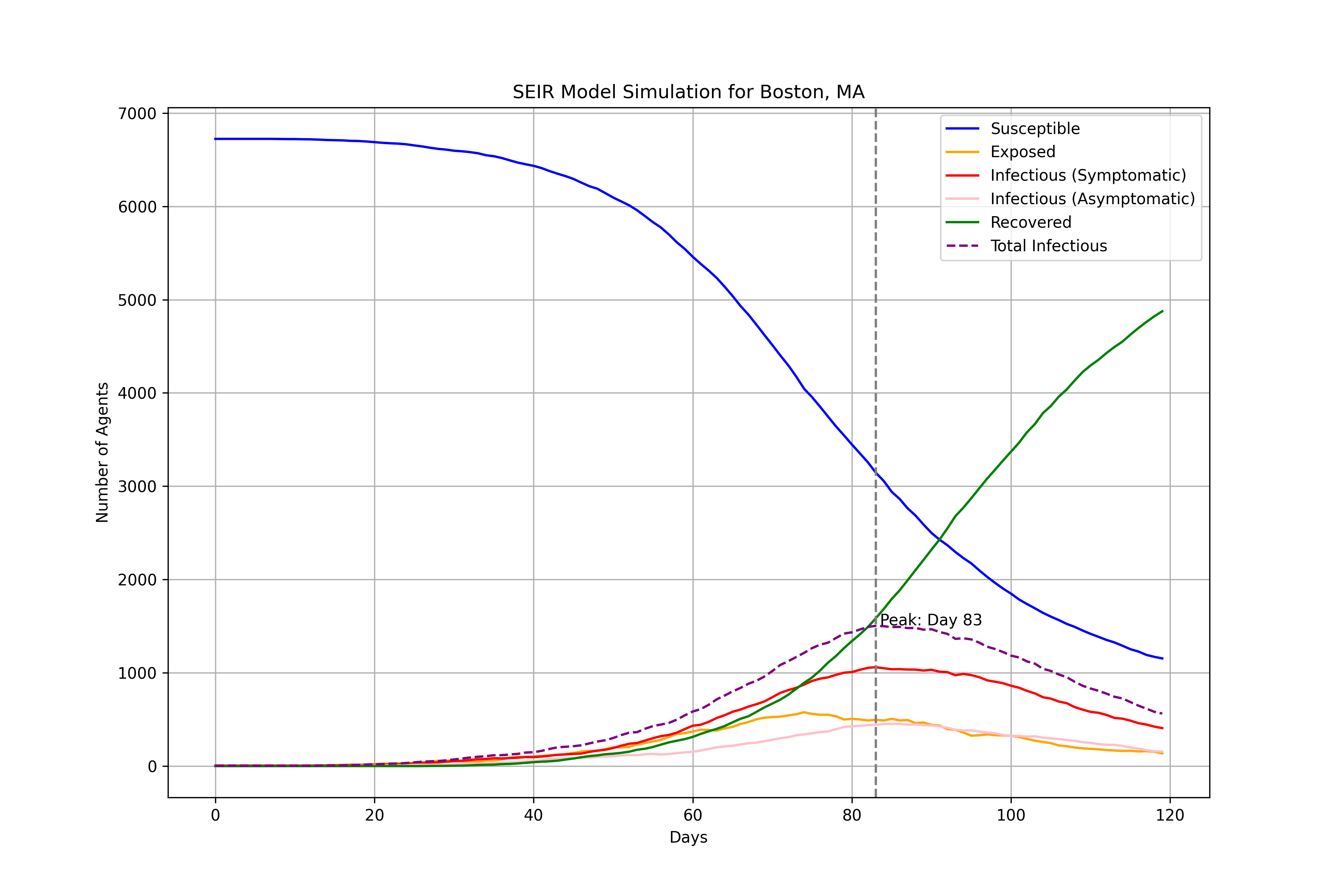
Methodology & Results
Our integrated approach combines geospatial road network data with agent-based modeling to create a realistic simulation of disease transmission in urban environments.
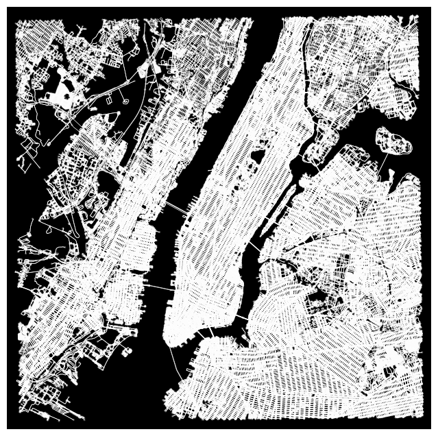
Road Network Extraction and Projection
We begin by anchoring our spatial domain at a central geographic point in Times Square, NYC (latitude 40.7580°, longitude -73.9855°). A bounding region is defined by a 500-meter radius around this point. We extract the corresponding road network data from OpenStreetMap, then project it to the Web Mercator coordinate system.
Agent-Based Simulation
Each agent represents an individual with attributes governing epidemiological status and behavior, including state (S, E, I, R), behavioral modifiers (vaccination, social distancing), and mobility (shortest-path movement unless quarantined). The simulation runs over 150 time steps with 4% of 5000 agents initially infectious.
Key Findings:
Network structure significantly influences transmission patterns, with higher connectivity leading to faster spread
Agent movement creates realistic contact networks that traditional models can't capture
Behavioral interventions show varying effectiveness based on urban density and network topology
Simulation Results
Our simulations reveal that integrating road networks and agent movement significantly enhances the realism of disease transmission modeling, moving beyond traditional homogeneous mixing assumptions. The visualizations below demonstrate the spatial and temporal dynamics captured by our approach.
Interactive visualizations and detailed analysis of the simulation results are presented in the following sections, showing the impact of different intervention strategies on disease spread.


Conclusion, Impact, and Future Work
Framework Summary
Our framework uniquely combines:
- Real-world geospatial networks
- Modified SEIR disease modeling
- Data-driven intervention analysis
Key Impacts
This approach provides:
- More accurate outbreak predictions
- Better policy evaluation tools
- Improved understanding of asymptomatic spread
Future Work
Planned developments include:
- Comprehensive sensitivity analyses
- Validation against empirical outbreak data
- Expanded policy scenario testing
Research Team
Meet the talented individuals behind this research project.
Dr. Sarah Tymochko
Hedrick Assistant Adjunct Professor
Ph.D. Computational Mathematics
University of Illinois at Chicago
Assistant Adjunct Professor
University of California, Los Angeles
Specializes in topological methods for time series analysis. Her work focuses on topological data analysis, dynamical systems, network science, and opinion dynamics.